


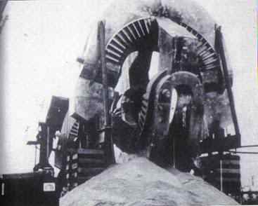
This massive piece of machinery was one of six excavated around 1990 from a great depth on secret government property in the United States, then promptly reburied in the same area. The enormous device dwarfs the dumpster and the crane shown to its left. Nobody has been able to definitively identify this mind-boggling machinery. What is even more peculiar is that this mysterious apparatus is covered with what appears to be hieroglyphic writing. Some skeptics have claimed it is nothing more than a large magnet used to produce a strong magnetic field needed for fusion experiments. In my book I point out the many problems with this claim. (ROTP:SMAM Pg. 212)
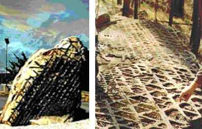
Mystery rock from Earth or alien spaceship? This gigantic boulder with its belly laced like an oversized waffle grill continues to baffle visitors who come to the West Virginia side of Jennings Randolph Lake. There have been numerous theories and speculation as to its origin, ranging from a pictograph made by prehistoric man, an Indian carving, the impression of the skin pattern of a giant lizard, or evidence of a visit to Earth by ancient travelers from outer space. Others, mainly among the professional community, attempt to explain it as a natural geological formation. Is this so-called "waffle rock" a natural geological phenomenon, ready mixed, blended and baked by Mother Nature for the puzzlement of the observer? Or, is the boulder actually evidence of alien technology sometime in our distant past? The precise and consistent "waffle-like" pattern appearance is highly unusual and looks almost artificial or manufactured. Geologists even admit that this type of formation is extremely rare - with possibly only one other known site in existence. It is curious that a rock formation is so unique that it cannot be duplicated by nature anywhere else on our entire planet.
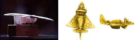
The object on the left was discovered in a tomb at Saqquara, Egypt and later dated as having been built around 200 B.C. The object on the right was one of many found in Central America and coastal areas of South America estimated to belong to a period between 500 and 800 A.D. The similarity to modern day aircraft is unmistakable. In fact scale model replicas have been built and successfully flown proving their aerodynamic capability. However, the important question is: how would ancient Egyptians or those people living in Central and South America know of aerodynamics and aircraft, and what would they need them for? These cultures were continents apart and supposedly unaware of each other, according to mainstream science and history. (EOLAC:CC Pg. 322)
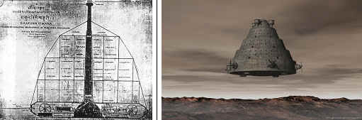
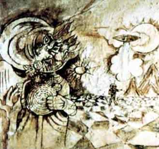
Ancient historical texts are filled with references that describe "flying wheels of fire", "pearls in the sky", and circles of fire". When Alexander the Great invaded India more than 2,000 years ago, he chronicled "flying, fiery shields" appearing in the sky which dove at his army. Ancient Tibetan and Indian texts go into great detail describing these flying machines, including blueprints of their design. The photo on the left is a Vimana vehicle as mentioned in ancient Indian Sanskrit texts from the time of the Rama Empire. This great civilization ended somewhere between 2500 B.C. and 4500 B.C. Some Sanskrit scholars claim that the Rama Empire thrived around 10-15,000 B.C. These Vimanas reportedly even carried weapons on board and were capable of traveling into outer space and underwater. (EOLAC:CC Pg. 326)

In the Cairo Museum and in other museums around the world there are examples of stoneware that were found in and around the step pyramid at Saqqarra. They show unmistakable tool marks of a lathe-manufactured item. At least one piece is so flawlessly turned that the entire bowl balances perfectly on a round tipped bottom no larger than the size and shape of the tip of a hen's egg. The only problem with this technology is that it wasn't invented until the 17th century with the arrival of the Industrial Revolution. What happened during the 3,000 years in between? (ROTP:SMAM Pg. 208)
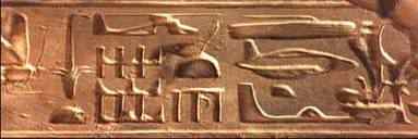
Various Egyptian hieroglyphs clearly depict modern day aircraft such as helicopters, dirigibles, and assorted other types of airships and craft. Why were they so familiar with flight and air travel? (EOLAC:CC Pg. 303)
This wall mural resides inside a temple in the goldmines of Kush. Notice the rocket standing upright and two figures standing to the right of it. (EOLAC:CC Pg. 303)
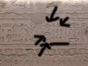
The Egyptian hieroglyphic shown in photo on left features two UFOs. This design has also been found in Mexican pottery and stonework. The technical detail in these two UFO shapes is amazing and they have no place in the minds of primitive people working in very crude circumstances. Advanced astronomical, mathematical and geometrical knowledge taught in schools today originated in Egypt. Where did it come from? This particular hieroglyphic definitely establishes that ancient Egyptians were in contact with some kind of flying craft from outside of Earth.
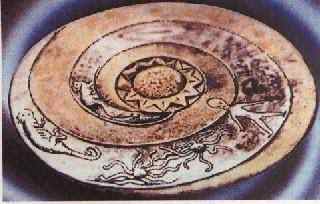
This plate, called the Lolladoff Plate, is a 12,000 year old stone dish found in Nepal. It clearly shows a disk shaped UFO. There is also a figure on the disk looking remarkably similar to a classic "grey" alien. Notice the spiral galaxy as well, with the alien inside it and the UFO at the beginning of it. It has been suggested that the galaxy spiral could be to tell us that they traveled here from another galaxy, or the spiral shape could signify energy or eternity. (EOLAC:CC Pg. 341)
Hundreds of these disks, known as Dropa Disks, were discovered in a man-made cave system in the Himalayan Mountains, on the border between China and Tibet. Inside of the caves were neat rows of tombs with short 4-foot 4-inch skeletons buried within. On the cave walls were carved pictures of the rising sun, moon, stars, the land, mountains, and lines of dots connecting the Earth and sky. Along with the disks, the cave drawings have been determined to be 12,000 years old. When the disks were closely examined in 1958 it was learned that each disk was inscribed with two fine grooves spiraling from the edge to a hole in the disk's center. Each groove consisted of a series of tiny hieroglyphs of unknown pattern and origin. (EOLAC:CC Pg. 296)
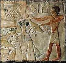
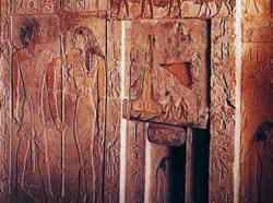
This photo is a relief found in the double mastaba of Akhti-Hotep and Ptah-Hotep. It shows servants offering food to Ptah-Hotep. Notice the similarity the figure facing forward has to a classic "grey" alien. (EOLAC:CC Pg. 303)
Skeptics point out that creative computer editing could be an explanation for extraterrestrials or flying ships appearing in ancient paintings, such as the one above. However, many paintings have hanged in museums and private collections around the world for hundreds of years, untouched by human hands, therefore not subject to modern computer-generated enhancements. These paintings also show strange disk-shaped objects in the sky - some during famous historical events. The ancient painting shown here was found by a joint Russian/Chinese mission in the caves of Fergana in Uzbekistan. Notice the hovering aircraft in the background along with what appears to be an astronaut underneath it. Estimates of the painting's age range from 2000 B.C. to 7000 B.C. (EOLAC:CC Pg. 301)
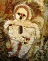

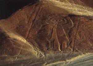
These Wandjina petroglyphs from Kimberley, Australia are about 5,000 years old and many believe are representations of extraterrestrial beings. (EOLAC:CC Pg. 385)
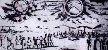
This picture is from 1697 and shows a UFO sighting over Hamburg, Germany. The two large objects hovering in the sky were described as "two glowing wheels". (EOLAC:CC Pg. 295)
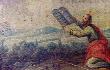
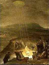
In this ancient painting Moses is depicted receiving the tablets of the Ten Commandments, with "flaming horns". Several other flaming objects appear in the sky before him. The date and artist are unknown. (EOLAC:CC Pg. 295)
This "Baptism of Christ" painting is from the Fitzwilliam Museum in Cambridge, England. A disk-shaped object is shining beams of light down on John the Baptist and Jesus. Painted in 1710 by artist Aert De Gelder it depicts a classic, hovering, silvery saucer-shaped UFO. What could have inspired the artist to combine these two subjects? (EOLAC:CC Pg. 295)
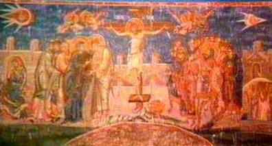
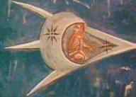
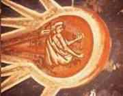
Frescos throughout Europe reveal the appearance of spaceships in the skies including this painting of "The Crucifixion" painted in 1350. The bottom two photos are enlargements of the top paintings upper left and upper right sections. It depicts a small human figure looking over his shoulder at another UFO - as if in pursuit - as he flies across the sky in what is clearly a spaceship. The leading aircraft is decorated with two stars, reminiscent of national insignia on modern day aircraft. This painting hangs above the altar at the Visoki Decani Monestary in Kosovo, Yugoslavia. (EOLAC:CC Pg. 295)
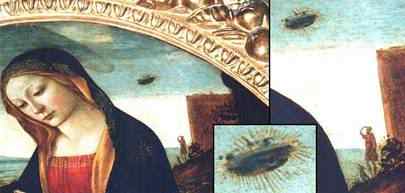
A 14th century fresco of the Madonna and child depicts, on the top right side just over her shoulder, the image of a UFO hovering in the distance. A blow up of the section with a man looking to the sky reveals amazing details including some windows or portholes visible in the UFO. It seems to indicate a religious involvement between UFOs and the appearance of the Christ Child. This painting is called "The Madonna with Saint Giovannino". It was painted in the 15th century by Domenico Ghirlandaio and hangs as part of the Loeser collection in the Palazzo Vecchio in Florence, Italy. (EOLAC:CC Pg. 296)
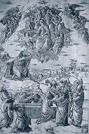

Painting on the left is from circa 1490 by an unknown artist. Several saucer-shaped UFOs (or clouds depending on your perspective) hover in the background along with groups of angels. Are we to infer from this that certain historical events where UFOs appear should be interpreted as holy or divine? Painting on the right is from 1486 and was done by Carlo Crivelli. It is called "The Annunciation with Saint Emidius" and hangs in the National Gallery in London, England. A disk-shaped object is shining a narrow beam of light down into Mary's crown chakra. (EOLAC:CC Pg. 296)
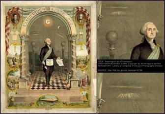
The top image on the left is of a lithograph residing in the Library of Congress archives. It was created in 1866 depicting George Washington as a Free Mason. What is striking about this painting is not the Masonic symbols, but rather the curious disc-shaped object located in the upper left inner-arch just above Washington's right shoulder. It seems to be shown with a Jacob's Ladder (a ladder to heaven as described in the Book of Genesis) rising up toward the strange object. The bottom image on left is a higher resolution enlargement which makes the object's shape and intention of the artist more obvious.
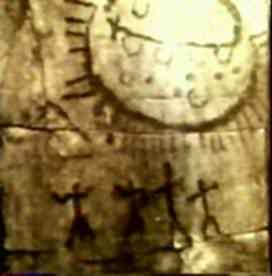
Picture on left is a strange-suited figure from Kiev, Ukraine that dates to 4,000 B.C. Picture on right is a 7,000 year old petroglyph discovered in the province of Queretaro, Mexico. There are four figures with outstretched arms beneath a large oval-shaped object with windows that is radiating what appear to be beams of light. (EOLAC:CC Pg. 295)
The first known civilization, the Sumerians, lived over 8,000 years ago. The little that we know of them was left behind on rocks. One of the most interesting and perplexing things they left behind was this image on an ancient cylinder. A perfect depiction of our heliocentric Solar System, with the Moon included is shown (the Sumerians considered the Moon a planet). Pluto and Charon are even depicted as a tiny pair. We only discovered Pluto in 1930, and in 2005 that it and Charon are a double planet. The most interesting part of this picture is the twelfth body way out in the distance to the right. This would be Sedna. Discovered in 2003, it easily could have been right around the area depicted in the Sumerian star map over 8,000 years ago. This proves that the first known civilization on Earth, the Sumerians, had knowledge that was just as advanced as our current knowledge, if not greater. The obvious question this prompts is: how did the Sumerians obtain such advanced astronomical knowledge? (EOLAC:CC Pg. 191)
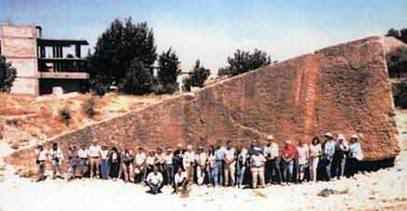
Conventional science and history have taught us that the oldest known civilization is the Sumerian. However, the ancient city of Tiwanaku located in Bolivia originally sat on a plain a few feet above sea level, and now is more than 13,000 feet above sea level. Tiwanaku is therefore older than the surrounding mountains which are 12,500 years old. After 50 years of study using mapping calculations and astronomical measurements archaeologist Professor A. Posnansky dated it back to possibly 15,000 B.C., making it the oldest known city in antiquity. How could a civilization that old have advanced knowledge of machining granite to modern-day precision tolerances? How could it have had the knowledge to transport blocks of stone weighing up to 800 tons to a mountain top 13,000 feet high? Modern history tells us that only hunter-gatherers were roaming the countryside at this time. (EOLAC:CC Pg. 138)
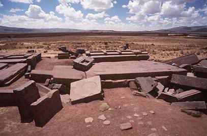
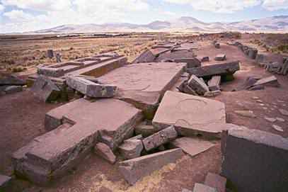
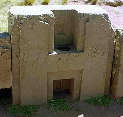
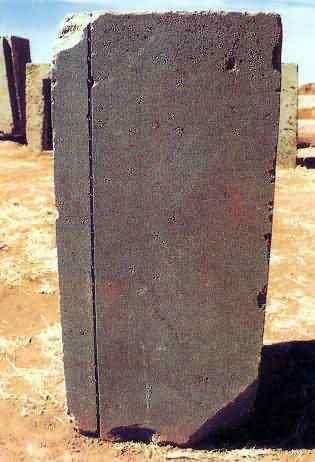
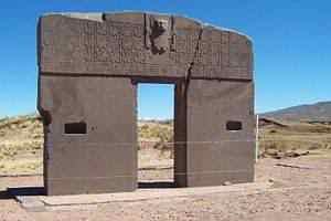
Puma Punku (4 photos on left) truly startles the imagination. It is part of a large temple complex or monument group that is part of the Tiwanaku site. It is situated near the southeastern shore of Lake Titicaca, and sits on a plateau of the Andes 12,600 feet high. One of the construction blocks weighs an estimated 450 tons (equal to nearly 600 full-size cars) and several other blocks lying about are between 100 and 150 tons. The quarry for these giant blocks was on the western shore of Lake Titicaca, some 10 miles away. But the real mystery lies in how Puma Punku was built. How were these blocks brought to a plateau over 12,000 feet high? There is no known technology in the entire ancient world that could have transported stones of such massive weight and size. The Andean people of 500 A.D., with their simple boats made of reeds, could certainly not have moved them. Even today, with all the modern advances in engineering and mathematics, we could not fashion such a structure. How were these incredibly large stones moved and what was their purpose? The dating of this site is considered so controversial, even impossible, that it has been ignored and censured by the scientific community for 50 years. At first glance Puma Punku doesn't look impressive - a hill as remains of an old decayed pyramid and a large number of megalithic blocks of stone on the ground, evidently smashed by a devastating earthquake. However, closer inspection indicates that these blocks have been fabricated using a very advanced technology. Cuts extending several feet in length that are laser-like in straightness; perfect 90-degree angles; deep machined pockets; joints so tight that a credit card wouldn't fit into them. Even more surprising is the technical design of these blocks as shown in these photos. All blocks fit together with an amazing level of precision. (ROTP:SMAM Pg. 143)
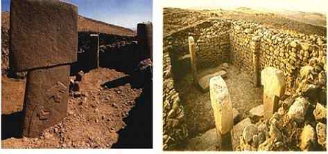
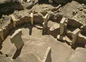
Göbekli Tepe is a hilltop sanctuary built on the highest point of a mountain ridge 10 miles northeast of the town of Şanlıurfa (Urfa) in southeastern Turkey. The site has been carbon dated to being at least 12,000 and possibly even 13,000 years old. That means it was built around 10,000 B.C. By comparison, Stonehenge was built in 3000 B.C. and the pyramids of Giza supposedly in 2500 B.C. Göbekli Tepe is the oldest man-made place of worship yet discovered. It is so old that it predates settled human life. It is pre-pottery, pre-writing, pre-everything. Göbekli Tepe hails from a part of human history that is unimaginably distant, right back in our hunter-gatherer past. It may very well be the oldest, most advanced site on Earth. It is almost 7,000 years older than Mesopotamia's Fertile Crescent, which is long believed to be the cradle of civilization. Perfect stone circles created from huge sculpted columns - 19 feet high and 15 tons per column. It has taken archaeologists 13 years to uncover just 5 percent of this civilization. Over this time not a single cutting tool or agricultural implement has been found. These megaliths just appear out of the darkness of the last Ice Age fully developed at a time when humans were only one step beyond the cave dweller stage. This proves that there were ancient civilizations possessing astounding sophistication at incredibly early periods in time. According to biblical tradition the world began around 4000 B.C. The foundation of Göbekli Tepe is 8,000 years before that. Clearly this contradicts our normal understanding of the evolution of civilization. Many of the animals carved into these gigantic monuments aren't native to this region of the world. What does this collection of animal and human forms represent? Göbekli Tepe is located only 350 miles from Mount Ararat, which many biblical scholars believe is the resting place of Noah's Ark. The animal carvings point to a time in the region's history when the indigenous animal population may have been of a totally different origin. But do these carvings provide proof of the Great Flood as described in the Bible? Do these stone columns contain the story of such a flood? If this is true then it would push back the date of the Great Flood to the end of the last Ice Age - far earlier than the biblical period. So who built Göbekli Tepe and for what purpose? Interestingly enough the reason for this ancient site being so well preserved is because it was buried under sand, purposely. Rather than destroying the monuments they were deliberately and strategically hidden under 20 feet of sand. But for what reason - to hide it from invaders or to preserve it for future use? (MO:THSR Pgs. 252, 355)
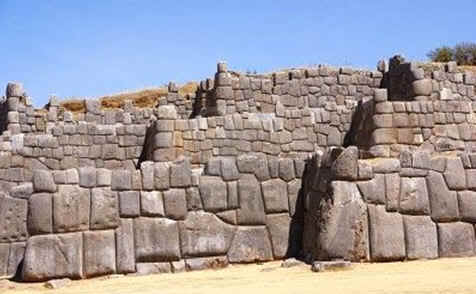
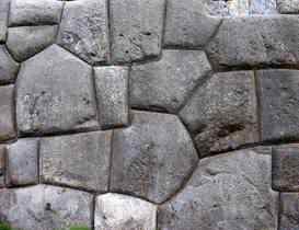
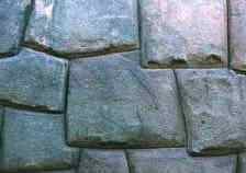
The ancient Inca established their capital city at Cuzco, Peru. Located at an elevation of 12,000 feet near Cuzco lies Sacsayhuamán. This immense fortress was constructed using massive stone blocks (photos on left). Nobody knows exactly who built Sacsayhuamán or how. Sacsayhuamán can be admired for the remarkable architectural engineering skills that were required in its creation. The Incas told the Spaniards that they weren't the ones who built Sacsayhuamán, but "the giants". In their mythology there were huge people living in the Cuzco area who carried the stone blocks and put them together. Many stones weigh over 50 tons and the largest weighs over 120 tons. How is it possible to move and position such large stones at such a high altitude? Modern day cranes couldn't reach these remote mountain regions. There are signs of thermal heat or energy being used on these rocks leading some to suspect that they may have been melted of liquefied allowing them to be easily manipulated. There was no mortar used in the construction. The blocks are so precisely assembled, like a jigsaw puzzle, that a credit card can't even be inserted between them. (MO:THSR Pg. 190)
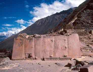
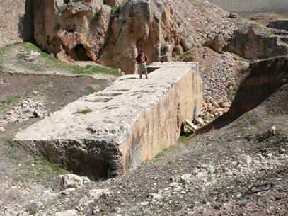
Located 9,000 feet above sea level in the Andes Mountains is the ancient city of Ollantaytambo, Peru. Once serving as both a temple and fortress, mainstream historians claim Ollantaytambo was built around 1440 A.D. by the Inca. However, some scholars believe Ollantaytambo was built upon the ruins of a far older city - one whose origins remain unknown. The earliest parts of Ollantaytambo are possibly 10,000 years old, if not older. But how could the earliest humans on Earth have produced such astonishing stonework with massive interlocking blocks precisely fitted together? How could they have constructed aqueducts and irrigation systems that still function today, or have moved and set colossal stones of granite each weighing more than 50 tons? Some of these massive stones were transported from another mountain, across a plain and river, and then up the mountain where they rest today. How were the ancient builders able to not only cut the stones with such high precision but also to move them up a mountain? Six of the giant slabs (top photo on left) on the site made of red granite were precisely fitted together in interlocking patterns in order to withstand the effects of earthquakes. The ability to move and perfectly fit stones weighing many tons so that a single human hair cannot fit between them is not a question of sweat and muscle, but rather a question of technology. And stranger still is the means by which the mammoth boulders are bonded in place, as if fused together by an unknown form of energy.
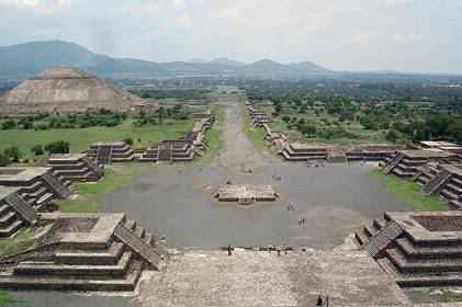
Teotihuacan is located 35 miles northeast of Mexico City. Established around 100 B.C., Teotihuacan was one of the largest cities in the ancient world with over 150,000 inhabitants at its peak. According to researches the advanced design of Teotihuacan suggests that its ancient builders had knowledge not only of architecture but of complex mathematical and astronomical sciences. There are numerous similarities to the great pyramids of Egypt. The same mathematics has been incorporated at both locations. The Khufu pyramid at Giza and the Sun Pyramid of Teotihuacan have the same size base. The Sun Pyramid of Teotihuacan is exactly half the height of Khufu's pyramid. Teotihuacan is built to a purposeful, specific layout. The Temple of the Sun, Temple of the Moon, and Temple of Quetzalpapalotl are in the same layout as the stars in Orion's Belt, which is the same formation as the three pyramids at Giza. (EOLAC:CC Pgs. 321,371)
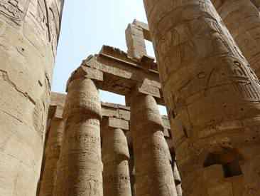
At the vast Karnak temple complex in Luxor, Egypt is evidence of machine technology. For centuries archaeologists and scholars have considered Karnak to be one of the most dramatic examples of the remarkable technological ability of early man. The hieroglyphics carved into the pillars and obelisks is clearly of an unmatched perfection. Experts believe the most impressive evidence of advanced machining can be found on Karnak's tall four-sided tapering monuments called obelisks. The obelisk is carved with the same inscription on all four sides, and each side is exactly the same - a mirror image. There are slots .140 inches wide and .50 inches deep that could only have been made using a rotating tool. The human hand is not capable of such precision carving. The tool marks and rotating impressions are still evident on the red granite surface. The tool kit that we see in museums, which the ancient Egyptians were supposed to have used, could not have been used to produce the results seen at Karnak.
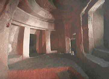
Scholars believe the early inhabitants of Malta migrated from the nearby island of Sicily in 5200 B.C. Today stone structures on the Maltese island of Gozo are considered by archaeologists to be among the greatest achievements made by ancient builders anywhere in the world. The temples on Malta and Gozo are more than a thousand years older than the pyramids of Egypt. They are the earliest monumental architecture in the world. There are engineering features built into these temples that are astonishing. Walls enclosing space, and paved walkways that had ceilings at one time, were among the most complex features found anywhere on Earth at the time. Built before metal tools or the invention of the wheel, experts are baffled by the scale of the construction and the use of vertically arranged monolithic stones, each weighing 20 tons. Some of these stones have been shaped to optical accuracy greater than what is achievable today. Further evidence of ancient technology can be found underground. In 1902 construction workers accidentally uncovered a mysterious underground sanctuary dating to 2500 B.C. Called the Hypogeum (photo on left) the subterranean structure was revealed to be three levels deep - all hewn from solid stone. It is estimated that the builders removed more than 2,000 tons of stone from the subterranean chambers to create a space that replicates the temples above ground. One of the greatest mysteries concerning the Hypogeum involves the acoustical properties in what is called the Oracle Room. A person's voice in the Oracle Room can be heard to carry throughout the entire complex with little variation. What was the reason for building this room, and where did they obtain this amazing acoustic technology? (EOLAC:CC Pg. 379)


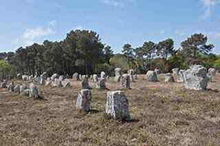
Carnac is located on the south coast of Brittany in northwestern France and is most famous for the Carnac stones (photos on left). This stone formation consists of a collection of 3,000 massive rocks arranged in rows, straight circles, squares and rectangles spreading across more than two miles of French countryside. Why would people spend so much time and effort in creating this? Archaeologists expect us to believe that humans one step removed from cavemen were quarrying these stones 100-350 tons in weight and then maneuvering them into precise alignment position. Some researchers believe that the stones are magnetically charged. According to the World Energy Grid Theory some areas on Earth are more magnetically charged than others and Carnac is one such geo-magnetic location that is harnessing the energy. If so where did these ancient people (4500 B.C.) get their knowledge from? The alignment of some of these stones represents mathematical formulas such as the Pythagorean Theorem. But how could these builders know of a theory 2,000 years before its discovery? These stones could have been transmitting energy that was detectable by travelers from the air (much like a modern day GPS system) and they were able to use it to navigate the entire planet. The formation and true impact of Carnac is only meaningful when viewed from the air. But why was it meant to be seen from the sky? Who was flying in 4500 B.C.? Carnac is only one of three ancient global sites that can be seen from outer space along with the Nazca Lines of Peru and the Great Wall of China.
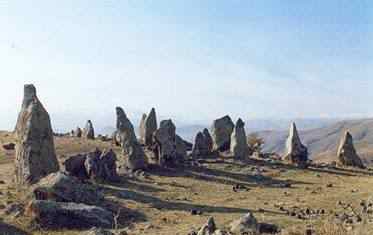
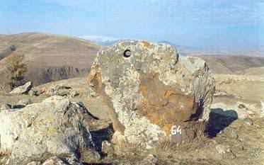
In the mountains of present day Armenia the first astronomical observatory Karahundj was built (photos on left). Mainstream archaeology cannot agree on who the builders were or who lived there. Also known as Armenia's Stonehenge, Karahundj is 7,500 years old making it 5,000 years older than the Great Pyramid of Egypt, 3,500 years older than England's Stonehenge, and 3,000 years older than Carnac in France. It may prove what some people already suspect - that Armenia is the true cradle of civilization. Located on a territory of 7 hectares, 223 huge vertical stones stand on a hilltop, 84 of them with holes drilled through them (bottom photo). This hole was used for viewing the sky and stars. Karahundj is commonly assumed to be an early observatory, evidence of ancient astronomical culture in Armenia. These stones have been attributed with mystical and cosmic powers. Armenian scientists in ancient times were capable of accurately measuring latitude, knew that the Earth was round, and had an accurate calendar. But how was all this possible 7,500 years ago? It is also believed that there was an astronomical relationship between the alignment of these stones and the constellation Cygnus.
Baalbeck is a city in eastern Lebanon famous mainly for its magnificent, well preserved Roman temple ruins. It was a flourishing Phoenician town when the Greeks occupied it in 331 B.C. They renamed it Heliopolis (City of the Sun). It became a Roman colony under the Emperor Augustus in 16 B.C. On its acropolis, over the course of the next three centuries, the Romans constructed a monumental ensemble of three temples, three courtyards, and an enclosing wall built from some of the most gigantic stones ever crafted by man. At the southern entrance of Baalbeck is a quarry where the stones used in the temples were cut. A huge block, considered the largest hewn stone in the world, still sits where it was cut almost 2,000 years ago. Called the "Stone of the Pregnant Woman" (top photo on left), it is 71 feet x 16 feet x 14 feet in size and weighs more than 1,000 tons. (EOLAC:CC Pg. 116)
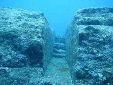
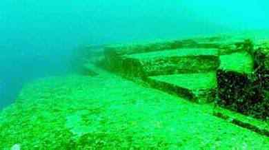
The mysterious undersea pyramid structure of Yonaguni, off the coast of Japan causes controversy. Is this a natural geological feature or a man-made structure which changes the history books as we know them? In 1986 a diver near the island of Yonaguni Jima, off the southern tip of Japan came across some unusual rock formations 82 feet below sea level. They appeared to be stepped structures with terraces and ramps. One of the largest pyramid structures is 600 feet wide and 90 feet high - containing five separate levels of stone blocks with what appears to be a road surrounding the structure. Tool marks and carvings have been discovered (and documented) upon the stones which indicate that they were constructed rather than being natural stone formations. Masaaki Kimura, a marine geologist from Japan's Ryukyus University, has been studying and mapping the site for almost 20 years. He believes that the site is over 5,000 years old - and was sunk during an earthquake 2,000 years ago. Others have estimated that the structure is far older, including Teruaki Ishii, professor of geology at Tokyo University. Ishii determined that the submergence occurred at the end of the last ice age - which was around 10,000 years ago. This would make it over twice as old as the pyramids in Egypt. If this is the case then our history books would have to be revised to take into account an advanced Eastern civilization, more advance than any early Western civilization. It is interesting to note that a number of tools have been discovered both on land and in the sea around the structure. Close to the pyramid structure, what is thought to be the carving of a human head has been found (several feet tall), along with numerous unknown hieroglyphs. (EOLAC:CC Pg. 374)
Researchers revealed in December 2009 the first images from the Caribbean Sea floor of what they claim are the archaeological remains of an ancient civilization. Guarding the location's coordinates carefully they believe the city could be thousands of years old - possibly even pre-dating the ancient Egyptian pyramids at Giza. The site was found using advanced satellite imagery and is not in any way associated with the alleged site found by Russian explorers near Cuba in 2001 at a depth of 2,300 feet. This site is much shallower. What has been found appears to be a tall, narrow pyramid; large platform structures with small buildings on them; standing parallel post and beam construction in the rubble of what appears to be a fallen building. There cannot be a post and beam without human involvement. (MO:THSR Pg. 62)
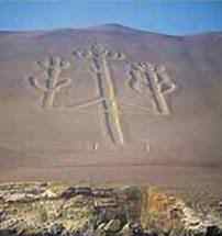
The Nazca Lines are a series of geoglyphs located in the Nazca Desert in Peru. They are believed to have been created between 200 B.C. and 700 A.D. Similar geoglyphs can be found throughout the world. They are noteworthy because they cannot be recognized as coherent figures except from the air, suggesting that they may have been built by a civilization having flying knowledge or capability. Why else would a culture go to such great lengths in creating these massive drawings? (EOLAC:CC Pg. 334)
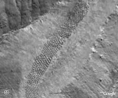
Most people know about the famous Nazca Lines. However, another less known unexplained mystery in Peru is located near Pisco Valley on a plain called Cajamarquilla. Thousands of man-sized holes are carved into the barren rock. These strange holes, stretching for a mile over uneven mountainous terrain, have been there for so long that the local people have no idea who made them, or why. And no one really was aware of them until the area was seen from the air. Archaeologists have speculated these holes were dug to store grain in. The problem with this theory is that there were many easier ways to create storage containers than the hard work and decades it must have taken to chip out all of these. It would have made more sense, assuming these were intended to store grain, to build several huge chambers. Any evidence of grain in them now would have been from subsequent generations who stumbled upon them and found they were convenient to use for grain storage. This wouldn't have been their original purpose by whoever built them. Another claim by archaeologists is that they might have been used as one-person tombs - vertical graves of some sort. But no bones, artifacts, scraps, inscriptions, jewelry and not even a tooth or strand of hair has been found in them. They have no covers to seal them as you might a tomb and no sacred history or even myth was passed down to label them as such. Some sections have holes in rigid and perfect precision. Some run in rows that curve up in arches, some in staggered lines. They vary in depth to about 6-7 feet yet some are merely shallow indents as if not completed - though surrounded by those that are. To this day no one has a clue what purpose these holes served, or who made them.
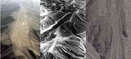
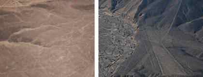
The Palpa Lines (photos on left) are less well known than the famous Nazca Lines, but are in many ways significantly more intriguing. There are numerous mountains with flattened tops, perfectly straight lines running across mountains and valleys as well as drawings and images similar to those found at Nazca. Were it not for the uneven surfaces, these "strips" may very well have been landing strips. Could these lines have been created by some kind of airborne machine? Archaeologists estimate that these figures and lines scraped into the hills of Peru's southern coastal desert predate the country's Nazca Lines. The drawings and lines are believed to have been created by members of the Paracas Culture sometime between 600 B.C. and 300 A.D. Another question raised by the Palpa Lines is that since they are located more frequently on hilltops and ridge tops, to what extent did the builders reshape the ridges to create the orientation and smoothness of the surfaces for their designs, and what equipment could possibly have been used in 600 B.C.? Much like the more famous Nazca Lines these lines cannot be recognized as coherent figures except from the air. (MO:THSR Pg. 277)
A wealth of thousands of ancient pyramids strategically situated around the world, and similarity in construction technique and physical appearance, is obvious proof that there must have been some common link between these civilizations. This knowledge must have been transferred and communicated from continent to continent, country to country somehow. At least twelve "Great" pyramids are now on record in six major regions of the world. Pyramids even exist on remote Pacific islands. Even without considering other data it is all but impossible to avoid the conclusion that this is clear evidence of diffusionism and global technological development unmatched to this day. (EOLAC:CC Pg. 370)
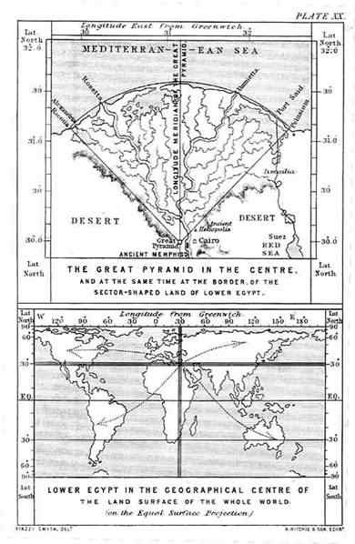
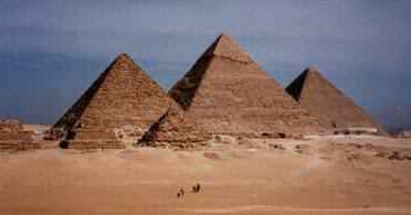
The Great Pyramid at Giza demonstrates a remarkable uniqueness in its placement on the face of the Earth. The Pyramid lies in the center of gravity of all the continents. It also lies in the exact center of all the land area of the world, dividing the Earth's land mass into approximately equal quarters. The north-south axis (31 degrees east of Greenwich) is the longest land meridian, and the east-west axis (30 degrees north) is the longest land parallel on the globe. There is obviously only one place that these longest land-lines of the terrestrial Earth can cross, and it is at the Great Pyramid! This is incredible, one of the scores of features of this mighty structure that begs for an explanation. Is the location of the Great Pyramid on Earth simply a coincidence? The image on left is The Plate XX from an original 1877 copy of Piazzi Smyth's Our Inheritance in the Great Pyramid. Charles Piazzi Smyth (1819-1900) was Astronomer Royal for Scotland and a highly respected scientist.
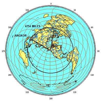
Detailed studies of the geographic alignment of famous ancient world sites have been conducted. According to the research the Great Pyramid (Giza) is aligned with Machu Picchu, the Nazca Lines and Easter Island along a straight line around the center of the Earth, within a margin of error of less than one tenth of one degree of latitude. Other sites of ancient construction that are also within one tenth of one degree within this line include Persepolis, the capital city of ancient Persia; Mohenjo Daro, the ancient capital city of the Indus Valley; and the lost city of Petra. The ancient Sumerian city of Ur and the temples at Angkor Wat are within one degree of latitude of this line. The alignment of these sites is easily observable on a globe of the Earth using a horizon ring (top image on left). Giza, Siwa, Tassili n'Ajjer, Paratoari, Ollantaytambo, Machu Picchu, Nazca, Easter Island, Aneityum Island, Preah Vihear, Sukhothai, Pyay, Khajuraho, Mohenjo Daro, Persepolis, Ur, and Petra are shown clockwise from Giza on the equal azimuthal projection. This projection is centered on the axis point located in southeastern Alaska. Distances to any location from the center of an equal azimuthal projection are equally scaled. Since all of the sites on the circle alignment are equally distant from the axis point at one quarter of the circumference of the Earth, the alignment forms a perfect circle halfway between the center and the outer edge of the projection. Critics of this "global alignment theory" claim that this is simply "cherry picking" ancient sites. However, it should be noted that this particular relationship between these particular sites is only one example of geographic alignment and is used strictly to illustrate the fact that an ancient sacred geometry existed on Earth. Similar relationships exist (not exactly the same as the one described above) between other ancient world sites. These include their location and positioning in respect to the planetary grid system. There is a definite, established relationship between almost every ancient Earth site on the planetary grid. Regardless of the ancient world site the fact that an alignment to some mathematical constant even exists is remarkable enough in itself. This could only have been achieved through an advanced knowledge of mathematics, geography, astronomy and with access to an aerial reconnaissance of the Earth many thousands of years ago. (EOLAC:CC Pg. 131)
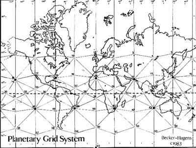
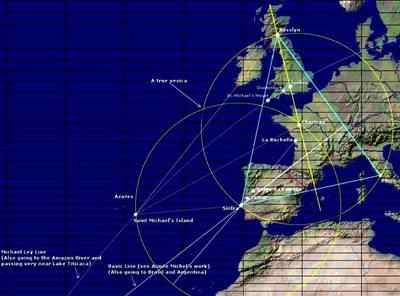
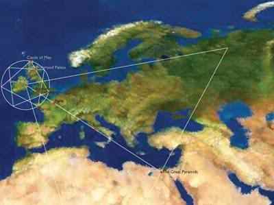
Ley Lines are alignments of ancient sites or holy places, such as stone circles, standing stones, churches, ancient monuments and megaliths stretching across the landscape. Ancient sites or holy places may be arranged in a straight line ranging from one or two to several miles in length. Simply an aligned placing of marker sites may identify a Ley, or it might be visible from the ground or air for all or part of its length by the remnants of an old straight track. The existence of alignments between sites is easily demonstrated. The Ley Lines and their intersection points are believed by some researchers to resonate extraordinary psychic or mystical energy. This belief assumes that points on lines have electrical or magnetic forces associated with them. Throughout England and Europe the most famous Ley Line sites are Stonehenge, Avebury, Glastonbury, Silbury, Carnac and other megalithic sites of unknown origin and purpose. Other ancient Ley Line sites around the world include Easter Island, Nazca, Ollantaytambo, Paratoari, Tassili n'Ajjer, Petra, Persepolis, Khajuraho, Pyay, Sukothai, Anatom Island, Machu Picchu, Cuzco, Bimini, Luxor, The Valley of the Kings, Mecca, Tazumal, Jerusalem, Xian, Taupo, Constantinople, in the Indus Valley Mohenjo Daro and Ganweriwala, the ancient Sumerian city of Ur, and Angkor Wat temples in Cambodia and Thailand, and the Angkor temple at Preah Vihear. The husband-and-wife team of Becker and Hagens developed a map detailing grid line alignment throughout the world (top image on left). Becker is a Professor of Industrial Design at the University of Illinois and Bethe Hagens is a Professor of Anthropology at Governors State University. It is immediately apparent from this map that the grid controls the positioning of continental landmass on Earth. Planetary energy grid theory operates through geometrical patterns that follow a specific symmetry linked to sacred geometry. Sacred geometry involves universal patterns used in the design of everything in our reality, most often seen in sacred architecture and sacred art. The basic belief is that geometry and mathematical ratios, harmonics and proportion are also found in music, light and cosmology. This system is considered foundational to building sacred structures such as temples, mosques, megaliths, monuments and churches. The grids meet at various intersecting points forming a grid or matrix. This is equivalent to the acupressure points on our bodies. These grid points can be found at some of the strongest power places on the planet. A few of these Ley Lines could be dismissed as a mere coincidence. However, what we are dealing with is literally hundreds of ancient sites throughout the world somehow mathematically aligned in a logical and deliberate sequence. The magnitude of their numbers and precision alignment can only lead to one conclusion - a relationship established in ancient times. (EOLAC:CC Pg. 133)
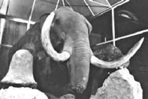
This is the famous Berezovka mammoth. It was found frozen in Siberia in 1901. There are many unusual characteristics regarding this mammoth, along with thousands of other prehistoric animals. Some of the enigmas surrounding these creatures include: carcasses and skeletons were found flash-frozen in a standing position; some of the woolly mammoths and woolly rhinos suffocated; millions of animals were entombed in rock-hard permafrost; partially preserved vegetation was found not only undigested in the stomach but also on the lips and between the teeth indicating their last meal. All of this points to an incredibly rapid freezing of the Earth - literally in seconds - not even allowing the animals to fully digest their meal. What unimaginable force of nature could have caused such an event? (EOLAC:CC Pg. 388)
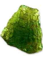
In various parts of the world such as the Euphrates Valley, the Sahara and Gobi deserts, Iraq, Scotland, Egypt and Turkey traces of this fused green glass have been found many feet below the Earth. In the Euphrates Valley the glass was discovered below archaeological remains that were known to be at least 8,000 years old, providing some indication as to the period when it was created. How did this strange green glass get there and what is it exactly? According to geologists subjecting sand and rock to exceptionally high temperatures causes this phenomenon. Experts estimate that it would take a fireball with temperatures in excess of 1800 degrees Celsius to turn sand and rock into molten lava that would then become glass when it cooled. The fact that the phenomena is so widespread across the globe either suggests (a) multiple and simultaneous meteorite strikes or (b) that there was a global nuclear war sometime in our ancient past. (EOLAC:CC Pg. 364)
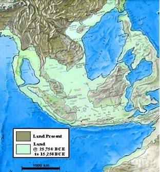
Anyone who inspects a map of the oceanic bottoms in the region of Indonesia such as the Ice Age Map of Indonesia shown here will readily concede that the South China Sea encircled by Indonesia indeed formed a continent-sized land mass during the last glaciation, which ended some 11,600 years ago. This map clearly shows the sunken continent of Sundaland in Indonesia. The map leaves no room for doubt about the reality of what we are affirming concerning Lemuria, Mu and Atlantis. It should be noted that this map – in contrast to most others presenting proposed sites for Mu, and/or Lemuria and/or Atlantis – is purely scientific, rather than a creation of someone’s imagination. It is based on the detailed geophysical reconstruction of the sea bottoms in the region in question, and portrays the areas of depth under 330 feet, which were obviously exposed during the Ice Age, when sea levels dropped by that amount and even more. The map shows a huge extension – of continental size – prolonged Southeast Asia all the way down to Australia. This continental-sized land was about two or three times larger than continental-sized India. It was also far larger than Australia. (MO:THSR Pgs. 306-307)
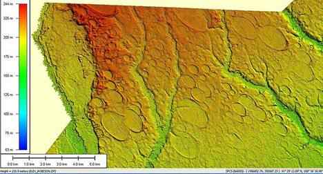
LIDAR elevation image of 300 square miles of Carolina bays in Robeson County, N.C. Carolina bays are elliptical landform depressions concentrated along the Atlantic seaboard within coastal Delaware, Maryland, New Jersey, North Carolina, South Carolina, Virginia, Georgia, north-central Florida, and northern Gulf of Mexico (photo on left). They vary in size from one to several thousand acres. About 500,000 of them exist in the classic area of the Atlantic Coastal Plain, often in groups with each bay invariably aligned in a northwest-southeast direction. Interestingly enough the creation date of the Carolina bays (12,900 years ago) coincides with the arrival by boat of travelers from the east in Mayan history, according to famed psychic and sleeping prophet Edgar Cayce. These travelers could have been fleeing the destruction of Atlantis by the comet. (MO:THSR Pg. 253)
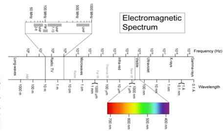
One reason (that is largely ignored) for the lack of abundant ancient evidence is because much of it was never (and currently is not) visible to the human eye. Only a small percentage of what transpires in our universe can be observed through the visible light spectrum (Electromagnetic Spectrum chart on left). Objects appearing or events occurring in the high-end of the electromagnetic spectrum (Ultraviolet, X-rays, Gamma-rays) beyond the capability of human sight cannot be witnessed. Ancient civilizations with the ability of such advanced technology would leave us little in the way of physical evidence. Quantum Theory has proven that speeds and events occurring outside the capability of human vision are definitely possible, and are taking place at this time in our universe (formation of back holes, galaxies). NASA is even aware of this and uses special cameras for filming these events in Earth orbit aboard the space shuttles. Therefore, assuming that this technology was available in ancient times, the possibility of no remaining physical evidence being available is perfectly understandable. (EOLAC:CC Pg. 233)


 bglavac